Are there solutions to coastal erosion?
Aminata Dagbani Chelpang, Accra, Ghana
March 11, 2023
Powerful waves cause coastal erosion and devour homes, historic monuments and farms along the coast. Violent flood waters, gushing from the hinterland, end up into the ocean,carrying with them homes, waste and arable land. These natural disasters inflict irreversible damage on the coastlines. The coastal zone only makes up seven percent of Ghana’s total land area, but is home to a quarter of its population. Today, Ghanaian authorities see coastal degradation as one of the country’s main environmental challenges.
Ghana’s coastline is eroding at an average rate of about two metres a year. But some smaller sites have recorded up to seventeen metres of erosion in a single year according to the The United Nations Educational, Scientific and Cultural Organization (UNESCO). UNESCO researchers found that 37 percent of coastal land has been lost to erosion and flooding between 2005 and 20171.
Global phenomenon, local impact
Ghana has 550 km of coastline, spread over four administrative regions: Central, Greater Accra, Volta, and Western Regions. The country also has offshore islands. These include the islands of Agbasiagba, Biobio, Bobowasi, Seva and Dodi. Known for their pristine beaches, these islands confront rising sea levels and coastal degradation. The country’s coastline is eroding at an average rate of two meters a year. But fragile sites have recorded up to seventeen meters of erosion in a single year. The 150-kilometre eastern coastline, which stretches from Aflao to Prampram, is the most vulnerable region2.
According to NASA satellite data3, global sea levels are rising primarily because of two factors related to global warming: the melting ice of glaciers and the expansion of seawater as it get warmer. In Ghana, industrial and manufacturing activities in the coastal regions, artisanal fishing, illegal and mining and population pressure exacerbate the negative effects of these natural disasters.
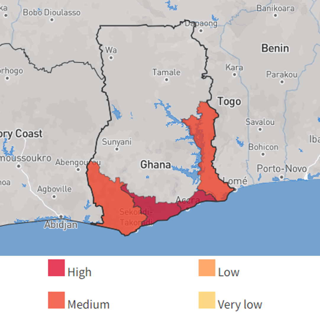
Coastal flood and erosion risks map

Source: thinkhazard.org/, gfdrr.org/ and World Bank
According to the ThinkHazard and the World Bank, potentially-damaging waves are expected to flood the coast at least once in the next 10 years. However, the recurrence of extreme climate events has shortened this cycle. The World Bank recommends that ‟project planning decisions, project design, and construction methods must take into account the level of coastal flood hazard”4.
Adaptation approach
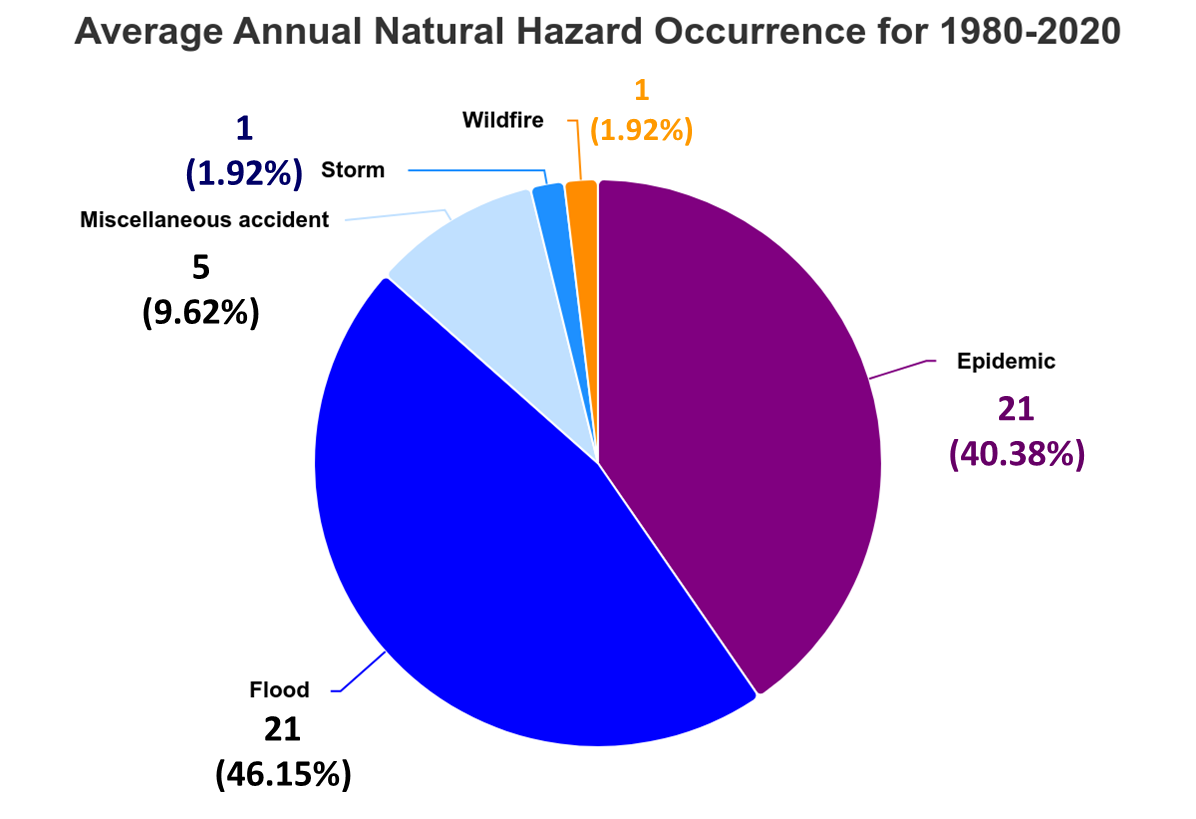
Ghana's proximity with the Sahel, in the North, exposes the country to drought, wild fire, rising temperatures, but also occasionnaly flash floods. The must therefore deal with a confluence of yearly natural disasters which have a mutually reinforcing effects. For example, extreme heat triggers regular wildfire. The fires eradicated the vegetation which protects the surface of the soil. After flash floods, the soil is washed away. River channels and basins carry flood waters straight to the sea. This vicious cycle repeats iteself with bigger magnitude as the negative effects of climate change intensify.
The Ministry of Works and Housing (MWH) is responsible for Government’s policies and programs for the sustainable management, protection and prevention works. In 2021 the MWH implemented protection projects in three regions covering a stretch of 41.4km. This means that 92.5 percent is still exposed to coastal degradation. However, adaptation activities in Ghana’s coastal areas have in the past suffered from poor coordination, with multiple agencies sharing overlapping and often contradictory mandates with no central coordination mechanism. The Coastal Development Authority was recently formed to address issues of coordination.

Source: World Bank5
The government of Ghana has implemented two adaptation approaches: reinforcing existing natural features and building manmade defenses against waves. In the two cases the government also tries to respond to local risks and taylor the solution incorprate local relief and geography. Over the past decade, Ghana built hard engineering structures while implementing soft adaptation strategies. Hard engineering structures include seawalls and beak waters which cost the country US$670 million. Research by the Food Agriculture Organization (FAO)6 showed that reinforcing existing natural protective features increases to the probability of re-establishing lost coastal areas after natural traumas. However, the FAO highlights alternatives to hardstructures and specifically mangrove forest and other coastal vegetation, which are natural means that reduce the power of waves and protect the coast from erosion.
Regional Cooperation
Ghana cannot fight coastal erosion alone. Coastal areas are naturally connected to each other. In the absence of regional coordination, a solution in one country may shift the problem to its neighbor. Ghana works with multilateral and bilateral donors to develop regional solutions. The country is a member of the World Bank-funded West Africa Coastal Areas Management Program (WACA). The program supports efforts to improve the management of shared coastal resources and reduce the natural and man-made risks affecting coastal communities. WACA facilitates the transfer of knowledge, foster political dialogue among countries, and mobilize public and private finance. An online platform provides mechanisms to scale-up knowledge, dialogue and finance.
In Ghana WACA programs aim to reduce risks of flooding and erosion. It planned to reinforce submerged native aquatic vegetation, mangrove protection and reforestation to serve as a buffer to inundation and sea-level rise. The program will also fill sand to restore shorelines between communities and the sea. It has erected small-scale localized infrastructure such as groynes or breakwaters for erosion control/sediment management.
Priority sites include communities in the (i) Pra River Estuary and (ii) left bank of Volta River Mouth including the stretch of coast of Anyanui-Agbledomi-Dzita. The project will also support socio-economic of affected coastal communities, especially women and indigenous peoples to support alternative livelihoods while ensuring local participation into conservation efforts.
Related Articles
BIBLIOGRAPHY
1❩ Kwasi Addo Appeaning - UNESCO (2021): Ghana’s coastline, swallowed by the sea - https://courier.unesco.org/en/articles/ghanas-coastline-swallowed-sea#:~:text=In%20recent%20decades%2C%20heavy%20waves,in%20the%20coastal%20ecology%20systems.
2❩ UNESCO (2021): Ghana’s coastline, swallowed by the sea, In UNESCO Courier, https://en.unesco.org/courier/2021-1/ghanas-coastline-swallowed-sea
3❩ https://climate.nasa.gov/vital-signs/sea-level/#
4❩ https://thinkhazard.org/en/report/94-ghana/CF
5❩World Bank (2022): Climate change knowledge portal - Ghana - https://climateknowledgeportal.worldbank.org/country/ghana
6❩ https://www.fao.org/3/ag127e/ag127e09.htm
